Badlands National Park in South Dakota is a surreal wonderland of rugged, eroded buttes, pinnacles, and spires, layered in colorful sediments. The park offers visitors a mix of breathtaking vistas/drives, hiking trails, and unique ecosystems. This guide includes information on scenic driving, short walks, longer hikes, and practical tips for visiting.
Located in southwestern South Dakota, Badlands National Park spans more than 240,000 acres of dramatic rock-scapes and mixed-grass prairie. The park is divided into two main units: the North Unit (accessible via paved roads and visitor centers) and the more remote South Unit (part of the Pine Ridge Reservation, requiring backcountry exploration).
Visitors typically spend the most in the North Unit, where the iconic Badlands Loop Road (Highway 240) winds through the park’s most famous overlooks and trailheads.

How Much Time Do I Need for Badlands?
Plan to spend at least a half day here, though a full day to 1.5 days will allow for more thorough exploration, time spent hiking, or getting those epic photos. But there are plenty of hikes, wildlife photo ops, and other activities to keep you engaged for much longer.
Logistics of Visiting Badlands
Getting There
There are three entry stations to Badlands NP, the Northeast Entrance (via I-90, Exit 131), the Pinnacles Entrance (via I-90, Exit 110), and the Interior Entrance (via SD Hwy 44).
The closest entrance from Rapid City, SD is the Northeast Entrance, which is about 63 miles, or an hours’ drive from the city. From the state capital of Pierre, it’s about a 2-hour drive to either of the Pinnacles or Interior Entrance Stations.
When to Go
Badlands National Park is best visited in the spring months of April and May or in fall, September and October. Temperatures ae moderate and the park is less crowded. Summer can bring scorching temps and heavy crowds, while winter brings frigid temps, snow, and icy roads.
Entry Fees
The current fee to enter Badlands National park is $30 per vehicle, which grants entry for 7 days. This park is included in the America the Beautiful Pass (also known as the National Parks and Federal Recreational Lands Pass), which costs $80/year and provides admission to all national parks and many other sites in the National Park Service. Visit their website to see all your entry / pass options and to purchase your pass online.
Prioritizing Your Time
The iconic drive through Badlands National Park is on the Badlands Loop Road. Driving this road is a must for any visitor. We’ve provided a stop-by-stop description – using our star rating system – of the Badlands Loop Road and its many stops. You need a minimum of 1-2 hours to drive this iconic route. Plan for more as you will want to pullover at many of the marked stops to take pictures, enjoy the views, and hike. If you are short on time, use our star ranking system to plan your visit – we’ve outlined 7 ★★★ stops – but try to save time if at all possible for one hike or nature trail.
If you have time for more – and I hope you do! – make sure to do some hiking and drive Sage Creek Road, a gravel route that starts near the Pinnacles Entrance and cuts west to Scenic, SD. From there, you can take SD 44 back to Badlands Loop Road near the Interior Entrance Station.
You can get the full experience of Badlands NP in 1.5 days.
Badlands Loop Road (Hwy 240)
The Badlands Loop Road is the main route through the park. It offers panoramic views of the Badlands’ buttes, spires, and canyons, and has frequent pullouts for photos and short walks/hikes. If you have limited time in Badlands National Park, this is your essential experience!
The route is 31 miles long, starting at the Pinnacles Entrance Station and ending at the Northeast Entrance Station. (This direction suits those coming to Badlands from the west. From the east, simply reverse the route.) The paved, two-lane road takes 1-2 hours to drive without stops, but plan for at least a half-day to fully enjoy the overlooks and short trails. If you want to do more hiking, which we recommend, plan for a full day. You won’t regret it!
Cell service is spotty, so download maps ahead of time. Gas and services are limited within the park; fuel up in Wall or Interior.
Pinnacles Overlook – Mile 1.1 ★★★
This is one of the most popular overlooks in Badlands NP. It provides a sweeping view of the rugged peaks and the Sage Creek Basin. Sunsets here are spectacular as the sun lights up the rock layers in shades of red and gold.

Tips: Look for bighorn sheep on the cliffs below. Arrive early or late to avoid crowds.
Ancient Hunters Overlook – Mile 1.7 ★
The Ancient Hunters Overlook stop highlights the park’s human history, where archaeological evidence suggests Native American hunters stalked bison thousands of years ago.
The view stretches across the eroded landscape.
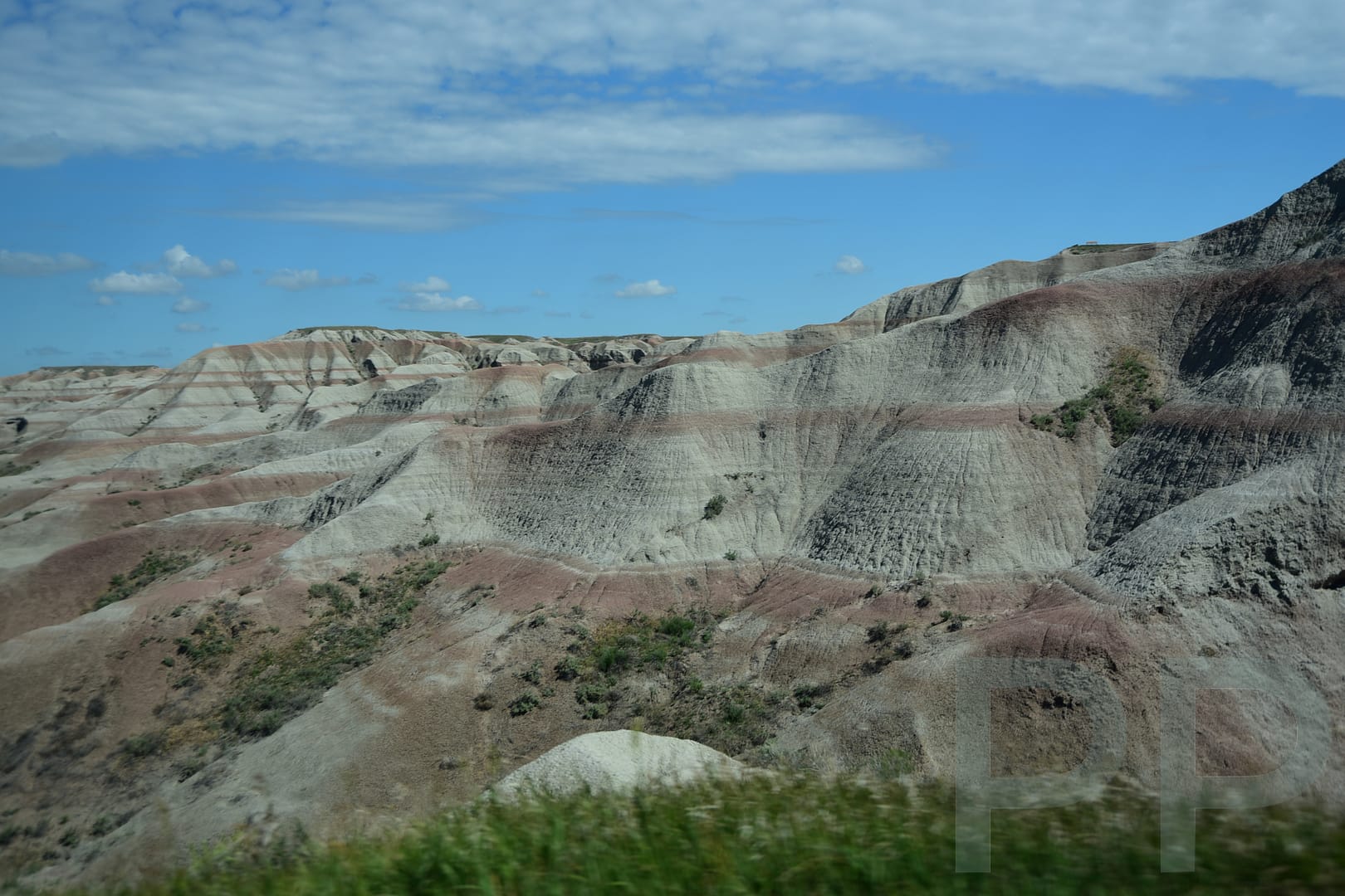
Yellow Mounds Overlook – Mile 4.4 ★★★
The Yellow Mounds Overlook is known for its vibrant, mustard-yellow mounds. The contrast with the surrounding red and gray buttes is striking. If you’re here in the morning or evening, you can get some great photos!

Conata Basin Overlook – Mile 5.0 ★★

This overlook offers a broad view of the Conata Basin, a grassy expanse dotted with eroded formations. This is a great place to spot prairie wildlife such as prairie dogs and grazing bison.
Homestead Overlook – Mile 6.5 ★
The Homestead Overlook showcases the mixed-grass prairie once farmed by early homesteaders. The view contrasts the harsh Badlands with fertile lowlands. Be on the lookout for pronghorn here.
Quinn Rd Prairie Dog Town – Mile 8.0 ★★ (★★★ for children)
This is a fun stop and a must for families! It’s entertaining to observe the busy prairie dog colony barking and scampering.

Burns Basin Overlook – Mile 9.1 ★★
From here you have views of Burns Basin framed by layered buttes and prairie. The stop is less crowded than other overlooks and provides a peaceful stop.
Prairie Wind Overlook – Mile 11.8 ★
Pull in here for views of grasslands stretching toward the horizon. Strong winds are common here, making it a fun stop on a warm day. On calm days, listen for the rustle of grass or birds singing.
Panorama Point – Mile 13.7 ★★★
The Badlands’ eroded formations are displayed on a grand scale at this must-see stop. Get out your wide-angle lens!

Bigfoot Pass Overlook – Mile 15.3 ★★
This stop is named for Chief Big Foot of the Lakota Sioux tribe. The overlook gives views of the White River Valley. A small picnic area makes it a great rest stop!
White River Valley Overlook – Mile 15.5 ★★★
Just a skip down the road from the last stop, this is a great place to stretch your legs. A short (0.1 mile), flat trail takes you to the overlook. Here, you see the White River’s wide valley cutting through the Badlands, with layered cliffs in the background.

Norbeck Pass – Mile 17.5
Here, the drive becomes incredibly scenic with sharp curves. The views of forested slopes transitioning into Badlands terrain are amazing. Take your time through here to enjoy the changing landscape.
Fossil Exhibit Trail Head – Mile 17.8
Another chance to stretch your legs and an interesting stop for kids! Here, a 0.25-mile, accessible boardwalk loop awaits. It displays fossil replicas from the park’s prehistoric past, including saber-toothed cats and ancient horses.
Saddle Pass Trail (Hike) – Mile 20.6 ★

This is a steep, 0.6-mile roundtrip trail climbing to a plateau with sweeping views. It’s a strenuous hike but hugely rewarding. You’ll need sturdy shoes.
Cedar Pass Lodge – Mile 22.4
The restaurant serves breakfast, lunch and dinner when the lodge is open.
Cedar Pass Lodge is the only lodging in Badlands NP. It provides lodging, dining, and a gift shop. Open seasonally, it offers cabins with air conditioning, TVs, mini-fridges, microwaves, coffee makers, and private bathrooms. Some cabins feature fireplaces or private balconies. Costs as of 2024 are around $240/night. Book early at the Badlands Cedar Pass Lodge website.
Ben Reifel Visitor Center – Mile 22.7 ★★
The visitor center offers exhibits on geology, wildlife, and history, and has park rangers onsite to answer all your questions. There is also a scenic overlook, a gift shop, picnic area, and restrooms.

Cliff Shelf Nature Trail – Mile 23 ★★
This is a relatively easy and very enjoyable walk. The 0.5-mile loop trail leads through a juniper grove and along a cliff, offering views of the Badlands Wall. There are some stairs so unfortunately this trail is not accessible for everyone.


Cedar Pass – Access to Trails – Mile 23.6
This area forms a transition zone between prairies and Badlands. Park here to access trails and overlooks. Look out for bighorn sheep!
The Door Trail ★★ for Hikers
This is an easy 0.9-mile round-trip trail leading to an observation area known as “The Door” in the Badlands Wall. It also provides amazing close-up views of rock formations.
The Window Trail ★★
This walk is 0.3-mile roundtrip, and is a fun walk for all ages. It leads to a natural “window” framing the Badlands and beyond.
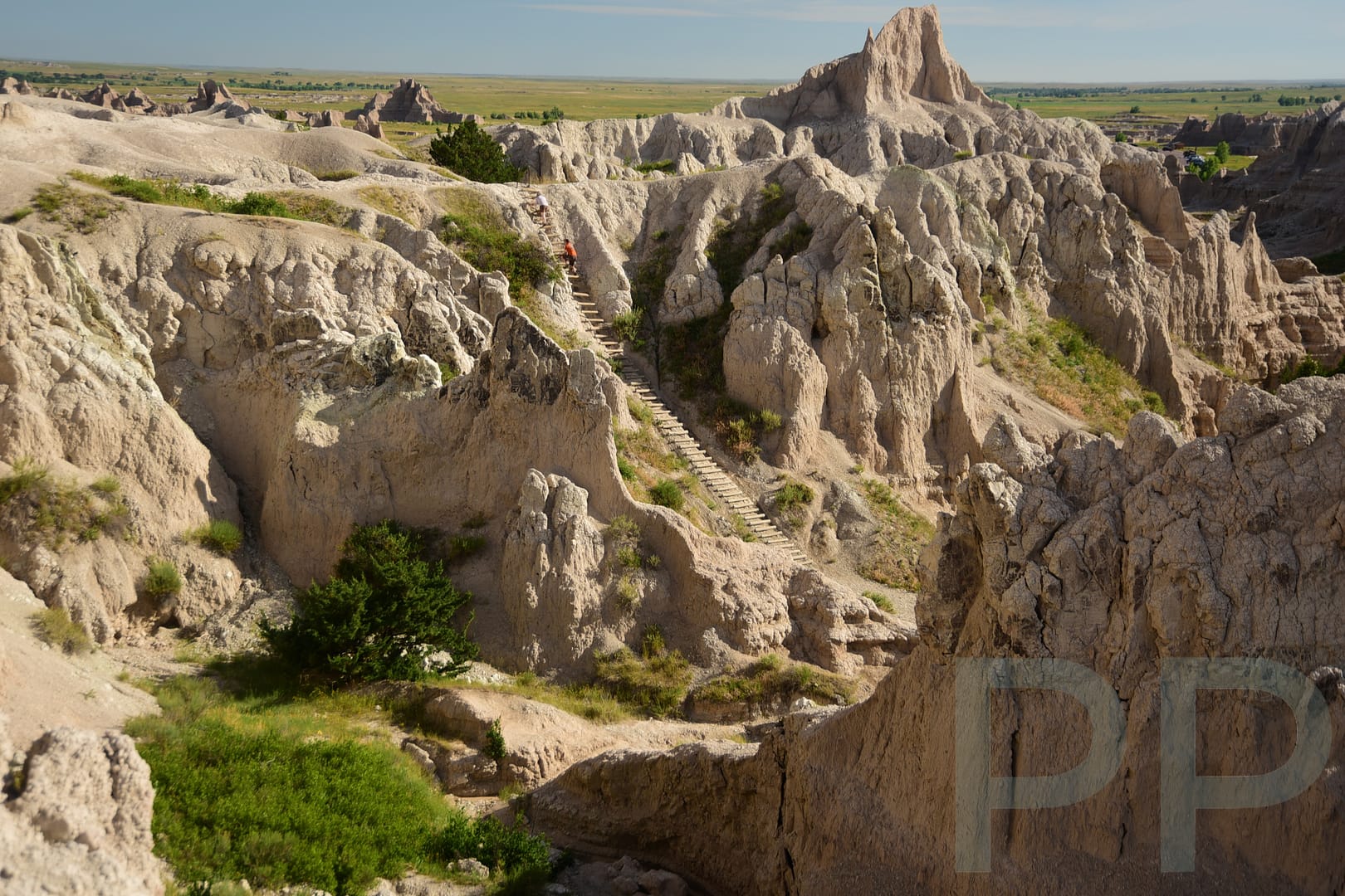
The Notch Trail ★★★ for Hikers
This amazing 1.5-mile trail is currently closed. Starting off from the trailhead, it utilizes a log ladder to climb up to a narrow path along a cliff edge. The trail ends at “The Notch” where you have dramatic views of the White River Valley.
Big Badlands Overlook ★★★
You’ve arrived at one of the park’s most iconic viewpoints, offering a stunning first glimpse of the Badlands’ jagged peaks and valleys. This is a must-stop for sunrise, or a stunning first stop if coming from the Northeast Entrance Station.

You’ve now completed Badlands Loop Road. See below for other the Sage Creek Road to Scenic, SD Drive.
Sage Creek Rd to Scenic, SD ★★
Sage Creek Road runs west off the Badlands Loop Road, just south of the Pinnacles Entrance Station, to Scenic, SD. This area of Badlands National Park is less crowded but offers amazing stops and views. The apro25-mile road is gravel, but generally passable in a car with reasonable clearance. Take it slow, as washboards and deep ruts form after rain.
The first stretch of Sage Creek Road is along the Badlands Wall. Here you can clearly see the contrast between the flat prairie to the north and the eroded rocky terrain to the south.
Badlands Wilderness Overlook – Mile ~3
There is a marked pull-off on the left. The overlook peers into the Sage Creek Wilderness Area with rolling grasslands and distant eroded hills
Roberts Prairie Dog Town – Mile 6
At about Mile 5, start looking for Prairie Dog Mounds. This is one of the best stops on Sage Creek Road, featuring a massive prairie dog colony. Watch and listen to the hundreds of prairie dogs – they are highly entertaining! Look for bison too as they often graze here. When we visited, there was a large herd of bison very nearby.
Hay Butte Overlook – Mile 9
Scenic stop with views over the Sage Creek Valley. While less captivating than than eastern park views, the Hay Butte Overlook affords a peaceful panorama.
Sage Creek Campground – Mile 12
Primitive campground with exposed sites, pit toilets, no water.
Sage Creek – Miles 13-14
Sage Creek is shallow and seasonal. There is no bridge and the crossing can flood after heavy rain. Never cross a flooded stream! Cottonwood trees and grasses flourish here.
Prairie – Miles 15-20
These miles are full-on prairie. Watch for pronghorn and soaring hawks.
To Scenic, SD (Jct with SD 44) – Miles 20-25
The remaining miles continue to cut through prairie, ending at Scenic, SD, which has one gas station and little else.
Scenic, SD to Ben Reifel Visitor Center ★
This 34-mile, paved route takes you back into the park via SD 44 and SD 240 (Badlands Loop Road) at the Interior Entrance Station.
The first 15 miles are through prairie and unremarkable. As you turn onto the Badlands Loop Road (SD 40), the scenery changes dramatically. Follow our Badlands Loop Road guide in reverse order as you travel the remainder of this route through the Interior Entrance to the Ben Eifel Visitor Center.
Other Related Guides (all coming soon!)
(See also our list of other National Parks guides (US and Canada).)