Idaho is an amazing place to visit. But it is a big state and to see the sights requires some time behind the wheel. Scenic drives are a great way to connect the elements of any trip itinerary, and that is particularly true in Idaho.
In this post we cover:
- The Sawtooth Scenic Byway
- The Ponderosa Pines Scenic Route
- The Payette River Scenic Byway
- and the US-95 Scenic Drive.
In the sections to follow, we begin with the Sawtooth Scenic Byway in the south. Note that these four connecting drives form a contiguous route from southern Idaho through central Idaho, ending in Lewiston in the North. (From Lewiston to Coeur d’Alene we recommend driving through the Palouse region – guide coming soon.)
The map below shows the overall route for the drives. (Note that the route generated by Google will not use and display some of the roads in the winter months if they are not passable or closed.) Map legend pin colors: green is Sawtooth, gold is Ponderosa, blue is Payette, and purple is US-95.
Download as a KML file and use in Google Maps, Google My Maps, OpenMaps, or other mobile apps. Start from the full screen view of the map.
This guide is part of our collection of Idaho guides, beginning with our Itinerary post, which provides you with an overview. Our Southern & Northern Idaho guides and our Craters of the Moon National Monument guide give details of great sights and activities.
In the sections below, we start in the south and work our way to the north.
Sawtooth Scenic Byway (ID-75)
The Sawtooth Scenic Byway, designated by Idaho Transportation Department, is part of the Idaho State Highway 75 (ID-75). It stretches through central Idaho, approximately 115 miles, from the town of Shoshone in the south to Stanley further north. This drive passes through some of Idaho’s most dramatic and varied landscapes.
Southern section of ID-75 between Shoshone and Ketchum/Sun Valley (~ 55miles)
The start of the scenic byway, Shoshone, is a small agricultural town at 3,963 feet elevation. It is known as a gateway to Idaho’s outdoor activities. Your drive begins in the high desert of the Snake River Plain, with sagebrush and lava fields. As you head north, the terrain transitions into rolling hills and the Wood River Valley.
Snake River Plain and Wood River Valley
The first stretch of this drive offers a few optional side trips worth considering. If you haven’t been to Craters of the Moon National Monument in southern Idaho, you might enjoy a stop at either the Idaho Mammoth Cave and Bird Museum or the Shoshone Ice Caves. Both are classic lava tube caves, with adult admission currently around $15.
Idaho Mammoth Cave is about 10 miles from the town of Shoshone, while the Ice Caves are roughly 16 miles out. The caves themselves are impressive, and the Bird Museum of Natural History at Idaho Mammoth Cave is packed with exhibits—more than you might expect. That said, if you’ve already explored the lava caves at Craters of the Moon, you may feel comfortable skipping these and continuing on your way.

Just a mile or so from Idaho Mammoth Cave and 18.5 miles north of Shoshone, is the Black Magic Canyon of the Big Wood River. This black basalt slot canyon has impressive and interesting formations. Although not as tall as some of the more well-known slot canyons, it is an other-worldly experience. Visiting the canyon is limited to fall and winter due to flooding from irrigation. Check out Black Magic Canyon Information for more.
If you can’t visit the canyon due to flooding (or potential flooding), a short drive away is the Big Wood River Bridge on Old Hwy 93 (Burmah Rd). From this bridge (not to be confused with the ID-75 bridge), you can see the slot canyon from above.
Sun Valley Area
Continuing up the byway, you drive through rolling hills and Wood River Valley farm land to the towns of Bellevue and Hailey (35 miles north of Shoshone). These towns accommodate skiers in the winter and have nice hotels, including the big chain hotels. There are also a few decent restaurants. We ate at the Sun Valley Brewing Co with burgers, beer, and some healthier options as well.
About 12 miles north of Hailey is Ketchum and the Sun Valley Ski area (~55 miles north of Shoshone and ~6.000 ft elevation). As you might expect, winter sports abound in the area but there is also plenty to do in the summer. Golf, hiking, and mountain biking are nearby.
Also of note, Ernest Hemmingway lived in this area and his grave is in Ketchum, not far off Hwy 75. This upscale area also boasts a vibrant arts scene and the famous Sun Valley Film Festival. With dates now in December, the festival is a well-regarded and is reportedly gaining attention within the film industry.
Northern Section of ID-75 between Sun Valley and Stanley
The scenic drive along Highway 75 (ID-75) between Sun Valley/Ketchum and Stanley is an amazing part of the Sawtooth Scenic Byway. This roughly 60-mile stretch offers stunning views of the Sawtooth Mountains, charming stops, and plenty of natural beauty. The drive typically takes about 1 hour straight through, but with stops, you’ll want to budget 2-4 hours to fully enjoy it.
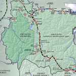
Leaving Ketchum, you head north into the Sawtooth National Recreation Area and Forest. The Sawtooth NRA has over 700 miles of trails, 40 peaks rising over 10,000 feet and 300+ high-elevation alpine lakes that add to the spectacular scenery and vistas. The Sawtooth NRA HQ & Visitors Center is 9 miles from Ketchum and worth a stop to pick up information about the area including hiking maps. The NRA and National Forest Guide is an excellent resource and covers stops along the Byway, flora & fauna, hiking, camping, rafting, lakes, fishing, etc. This map (click to enlarge) provides an overview of the scenic byway and the beginning of the Ponderosa Pines Scenic Route described below.
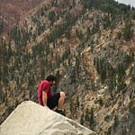
Hikes in the Sawtooths near the Byway
For a chance to stretch your legs, here are some day Hikes Near ID-75:
TRAIL | MILES (one-way) | TRAILHEAD LOCATION | HIGHLIGHTS |
Eagle Trail | 3.0 | South of Hansen on Rock Creek Road near Pettit Campground Hiking trail near the head of Rock Creek on the Minidoka RD | Pleasant walk in subalpine environment. Elevation gain is negligible--easiest |
Fishhook Creek | 3.0 | Hwy. 75 to Redfish Lake Rd. to Redfish Trailhead | Horse and hiking trail in the Redfish Lake Lodge area of the Sawtooth NRA. Accesses a beautiful meadow with views of the Sawtooth peaks on the edge of the Sawtooth Wilderness. Trail passes through lodgepole pine and aspen stands. Elevation gain: 380'--easiest |
Horton Peak | 2.5 | Hwy. 75 to Valley Rd; 5.5 miles to trailhead | This steep trail on the east side of Sawtooth Valley in the Sawtooth NRA is very dry-bring water. The reward is the 360 degree views of the White Cloud and Boulder Mountains and the Sawtooth Valley. An historic fire lookout is at the summit. Elevation gain: 2750'--most difficult |
Fourth of July/ Washington Lake | 2.0 | Hwy. 75 to 4th of July Creek Rd; 10 miles to trailhead | Popular hiking and motorcycle trail in the White Cloud Mountains. A lovely hike for seeing wildlflowers- wildlife- and wonderful views of the lakes and surrounding peaks. Best from late June-October. Elevation gain: 450'--more difficult |
Titus Lake | 2.5 | Trailhead is adjacent to Hwy. 75 south of Galena Summit | Discover an intriguing emerald pool in the Smoky Mountains just south of Galena Pass on the Sawtooth NRA. Elevation gain: 500'--easiest to more difficult |
Baker Lake | 1.6 | Hwy. 75 15 miles north of Ketchum; 10 miles on Baker Cr. Rd. to trailhead | This alpine jewel reflects the surrounding granite peaks and offers great fishing. It is located on the Ketchum RD. Elevation gain: 846'--easiest to more difficult |
Norton Lakes | 2.0 | Hwy. 75 15 miles north of Ketchum; 7 miles on Baker Cr. Rd.; 1 mile on Norton Cr. Rd. to trailhead | This horse and hiking trail on the Ketchum RD offers alpine lakes and a good chance of seeing mountain goats. It is a less crowded opportunity than nearby Baker Lake. Elevation gain: 1500'--more difficult |
Galena Area
After the Visitor Center, ID-75 climbs in elevation toward Galena Pass (mile marker 154). On the way there are pull-offs with views of the valleys and mountains. Billy’s Bridge Goat Viewing Site is one of the pull-offs, on the right as you head north, about 10 miles from the visitor center. Next, after passing Galena Ski Lodge, the byway winds up to the Galena Pass (8,701′ elevation), 22 miles from the Visitor Center. One mile after the pass is the Galena Pass Overlook on the left, with great views to the east.
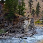
Not far after Galena Pass, are the headwaters of the Salmon River. The byway begins to follow the Salmon River on its way to Stanley.
The drive from the Galena Pass to Stanley (6,290 ft) is about 30 miles and is filled with mountain views. For more details on activities at Redfish Lake (mile marker 185), not far off the byway, and Stanley, see our Southern Idaho post. Also covered in this post is the phenomenal Iron Creek Trail hike to Sawtooth lake (~10 miles round trip).
Ponderosa Pines Scenic Route ID-21 and Lowman-Banks Road (ID-17)
The drive from Stanley to Banks offers a stunning journey through diverse landscapes. Below is a detailed description of the approximately 100-mile drive which takes about 2.5–3 hours without stops. The route is composed of the Ponderosa Pines Scenic Route (ID-21) and Lowman-Banks Road (ID-17).
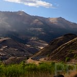
The Ponderosa Pine Scenic Byway (ID-21) begins in Stanley and heads southwest toward Lowman (3,776 ft), covering about 75 miles. The two-lane byway winds through high-elevation forests of ponderosa pine, Douglas-fir, and subalpine fir, and the occasional open meadow. It also follows the South Fork of the Payette River for portions of the drive, offering scenic views of clear waters and rocky canyons. Early on, the byway showcases the dramatic vistas of the Sawtooth Mountains. Then it transitions to forested foothills as you descend from the higher elevations through the Boise National Forest.
Below are key points of interest along this route, starting from Stanley and heading west to Lowman, with approximate mile markers where available. Note that some points are slightly off the main highway but accessible via short detours.
Stanley Area
Near Stanley is the alpine Stanley Lake. Take the 3-mile spur road left off ID-21, four miles west of Stanley (~ mile marker 123). In addition to the beauty of the Lake and McGown Peak (9,860 ft), there are an assortment of recreational activities featuring swimming beaches, boat ramps, three campgrounds, and trails into the Sawtooth Wilderness. This area can be an active stop.
Central Section of the Byway
After leaving the Stanley area, ID-21 loops to the north and then back south before bending back west toward Lowman. Another place to access the Sawtooth Mountains is near Grandjean (turn off near mile marker 93). There are great hikes in this area, including a trail up to Sawtooth Lake. See our guide to hiking to the lake from the east via Iron Creek in our Southern Idaho post.
Shortly after the turn off to Grandjean, the byway begins to follow the South Fork of the Payette River. Then the route (ID-21 and ID-17) follows this beautiful river all the way to Banks.
Another great place to stop is the Banner Creek Summit (near mile marker 105, ~7,056 ft), the highest point on the byway. There is a rest area and panoramic views of the surrounding Challis National Forest and Sawtooth Mountains. We did not visit during the fall, but the color of the aspens is said to be fantastic in October.
As you drive toward Lowman, to the north lies the Frank Church – River of No Return Wilderness area, the largest in the contiguous 48 States. This 2.3 million acre wilderness is accessible from ID-21 via numerous roads (many unpaved). It is also accessible from scenic Highway US 95, discussed later in this post.
Near Lowman
Before you get to Lowman, you pass Kirkham Hot Springs (mile post 77, ~38 miles from Stanley). We stayed here a night and bathed in the springs. Very nice! (see our Southern Idaho post).
Along the byway around Lowman are the seven Lowman Burn Interpretive Pullouts (Milemarkers ~73–79) with exhibits describing the 1989 Lowman Fire, which consumed 72 square miles and 26 structures. These pull outs are also a good place to see the South Fork of the Payette River, with its emerald-green, clear waters. There are rafting trips available in the area.
Banks-Lowman Road (ID-17), aka Wildlife Canyon Scenic Byway: Lowman to Banks
The Banks-Lowman Road stretches about 25 miles from Lowman to Banks (3,488′), connecting ID-21 to ID-55. This two-lane road follows the South Fork of the Payette River, winding through scenic river canyons and forests. The landscape features rugged cliffs, dense pine forests, and occasional glimpses of the river’s whitewater, popular for kayaking and rafting. More hot springs, particularly those near Bonneville Campground, are accessible along this stretch.
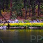
There are scenic views along the deep canyon with foliage varying from the tops of the mountains down to the river’s edge. Wildflowers abound in the spring and summer along the road and the river.
Banks-Lowman Road is narrower than ID-21, with some tight curves, but it’s paved and accessible year-round.
Payette River Scenic Byway (ID-55): connecting drive from Banks to Riggins (113 miles)
The Payette River Scenic Byway from Banks to Riggins offers a great drive along Idaho Highway 55, with a continuation on US-95 (described below), showcasing whitewater rivers, national forests, and charming towns. This route, part of the broader 112-mile Payette River Scenic Byway, has recreational and historical points of interest. Below are key highlights for the stretch from Banks to Riggins.
The route from Banks to New Meadows is approximately 80 miles along Idaho 55, with an additional 33 miles on US-95 to Riggins, totaling about 113 miles. The drive takes roughly 2.5 hours without stops, but plan for 4 hours to enjoy the sights.
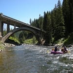
Banks is a small community known as a gateway to Payette River adventures, and as such is a hub for whitewater enthusiasts. The town is located at the confluence of the North and South Forks of the Payette River. The Main Payette offers Class II-III rapids, ideal for families and novice rafters. The put-in point here is a bustling spot during rafting season (June to mid-September). It’s a great place to watch or join guided float trips. The area around Banks features dramatic canyon landscapes where the river narrows, offering picturesque views of the Payette’s whitewater.
Smiths Ferry Area
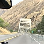
About 20 miles north of Banks is the area of Smiths Ferry, with several points of interest. First, Rainbow Bridge is a historic concrete arch bridge built in 1933, spanning 410 feet across the Payette River. It’s a National Register of Historic Places landmark and a frequent subject in photography. A narrow pullout just before the bridge allows for photos, but walking across is unsafe due to its narrow design.
The Payette River calms and broadens at Smiths Ferry, with sandbar islands perfect for relaxing or picnicking.
On the west side of Idaho 55, is a winter recreation hub called Wellington Snow Park with access to 400 miles of snowmobile trails, 250 miles of which are groomed. The Winter Wonderland Trail starts here, winding through scenic backcountry toward Cascade and Donnelly.
Donnelly (30 miles north of Smiths Ferry)
Further north on ID-55, before Donnelly, is Lake Cascade with a state park and it’s various recreational units. If you have limited time, you should save it for Ponderosa State Park further up the road.
The surprising Historic Roseberry site is 1.5 miles east of ID-55 on Roseberry Road. This turn-of-the-20th-century Finnish homestead showcases Idaho’s early settler life. The small park features the Roseberry General Store, Valley County Museum, Finnish Church and Cemetery, and a restored barn amphitheater. The homestead is worth a stop if you are interested in the region’s history.
Ponderosa State Park (McCall, ~15 miles north of Donnelly):
On a peninsula in Payette Lake, this park offers stunning views from Osprey Point, hiking, biking, and canoe/kayak rentals. Winter activities include skiing and snowshoeing. Wildlife like bear, deer, and osprey are common.
McCall’s pedestrian-friendly downtown features cafes, breweries, museums, art galleries, and a farmer’s market. Try a Mountain Size Scoop at Ice Cream Alley or a pint at a craft brewery.
Zim’s Hot Springs, in New Meadows (west of McCall ~15 miles), is just off of ID-55 and is a year-round natural pool. Historically used by Native Americans and early settlers, the pool is now open to the public (reservations required).
This stretch of the Payette River Scenic Byway, from Banks to New Meadows, extended via US-95 to Riggins, combines thrilling outdoor activities, rich history, and natural beauty, making it a worthwhile Idaho road trip. For more details, check resources like payetteriverscenicbyway.org.
US Highway 95 Scenic Drive – “River of No Return” Canyon
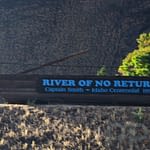
The drive from Riggins to White Bird on Hwy 95 is definitely in the scenic drive category. This 30-mile section of US Hwy 95 runs through a mile-deep canyon, river rapids, interesting towns, historical sites, and numerous recreational opportunities. From the south, starting at New Meadow ID, Hwy 95 follows the Little Salmon River. At Riggins, both the Little Salmon River and Hwy 95 join the Salmon River, which then flows north to White Bird. After White Bird, the river and highway roll on toward Lewiston ID, where the Salmon River then flows into the Snake River. So, this amazing stretch of Hwy 95 runs alongside the Salmon River, nicknamed the “River of No Return.”
History of “River of No Return”
The river has interesting history, particularly the section from Riggins to White Bird. It gets its nickname since boats that made the trip from Riggins to Lewiston could not return up stream due to the rapid current. The elevation drop from Riggins to the mouth of the river near Lewiston is nearly 4,000 ft, and from the head waters, a drop of around 7,000 ft. The section from Riggins to White Bird is particularly fast-flowing with Class II and III rapids. Of course, the name Salmon comes from the fact that Steelhead Salmon fight their way from the Pacific Ocean all the way to this river to spawn.
There was an historic trip down the river (north) from the city of Salmon to Lewiston by Clyde Smith and his son Don I. Smith (see his book) on a specially built “long barge” in 1946. This was not the first completed trip but was the first to demonstrate and time the 325-mile trip, taking 14 days. There is a replica of the barge on display at the City Park in Riggins.
Riggins Area
Riggins is a great place to base for whitewater rafting or jet boat tours on either the Salmon or Snake Rivers. There are accommodations, restaurants, and supplies and a number of other excursions, in addition to the drive up Hwy 95. For example, both the Riggins Hot Springs and the Rapid River Fish Hatchery are less than 30 minute drive.
Heading north up the highway, in under 2 miles you will come to the Time Change Bridge. Crossing the bridge, you enter the Pacific Time Zone. By the way, Riggins is the northwest-most town in the Mountain Time Zone. As you continue further north, there are various opportunities to pull off to take take in the views and get pictures. About 5.5 miles from Riggins there is a good spot to stop with a bend in the river where three creeks flow in.
Lucille and White Bird
The town of Lucille is about 9.5 miles from Riggins and offers more scenic stops as well as a bridge to cross the river and drive over to the Snake River (17 miles, gravel) via Cow Creek Rd. Some Snake River tours through Hells Canyon leave from this area (see our post). At about 24 miles, the Skookumchuck Recreation Site along the river is another nice spot.
As you near White Bird, the highway leaves the river for a few miles. But at almost 27 miles from Riggins you can turn left on to Old Highway 95 and stay along the river. You will pass Copperville on the other side of the river and then wind along White Bird Creek into town, passing under the 95 Bridge.
White Bird is a charming, picturesque town that provides another good base for exploring the area. (See our description of White Bird and a river excursion in our Northern Idaho post.) Less than 5 minutes north of town the White Bird Battlefield Historical Marker and overlook is another good spot to stop. The markers describe the victory of the Nez Perce over the US Army in 1877, in the first battle of the war.
The drive on to Lewiston is beautiful as well. As you leave White Bird, the canyon opens to rolling hills and farmland.
We hope you enjoy these scenic drives and our guides. These drives together provide showcase the amazing landscapes in Idaho. If you have other suggestions for drives, please let us know.
Related Guides
Idaho Itinerary: Outdoor Adventure and Culture
Planning a Visit to Craters of the Moon National Monument and Preserve, Idaho